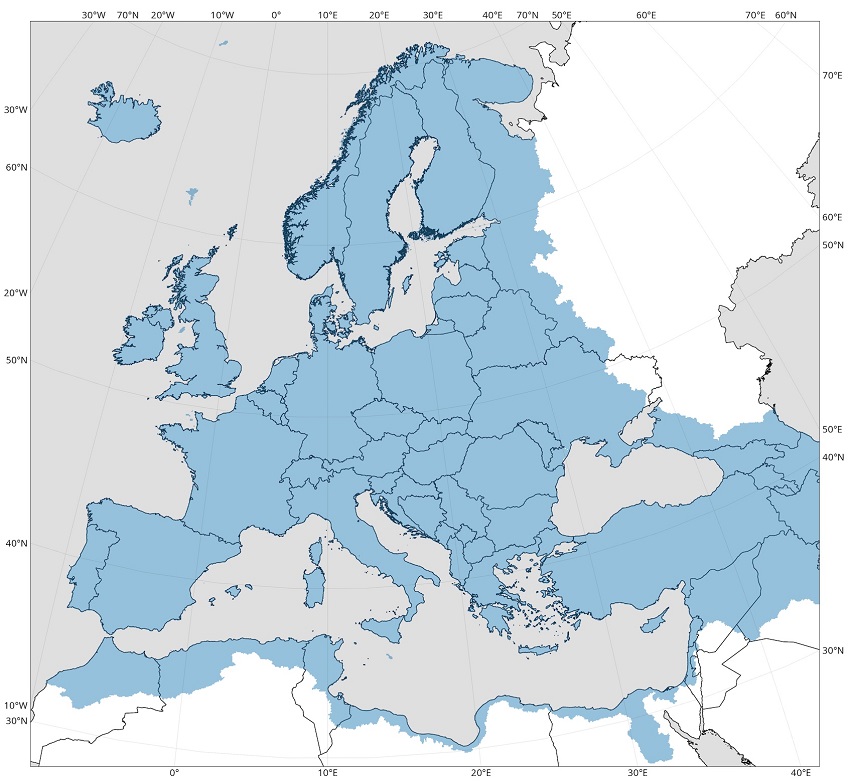
The European Flood Awareness System (EFAS) is one service of the Copernicus Emergency Management Service (CEMS). It is designed to support preparatory measures for flood events across Europe, particularly in large trans-national river basins.
To provide information on upcoming flood events, EFAS relies on a hydrological forecasting chain

The EFAS hydrological forecasting chain
There are key elements in the EFAS production chain: the meteorological forcing and land surface data; the hydrological models; and the EFAS forecasts and products.
The meteorological forcing and land surface data
The meteorological forcing data are all the information necessary to produce hydrological simulations.
- Historical hydro-meteorological time series records: they are used to calibrate and validate the hydrological model, and to define the flood thresholds used to derive EFAS products. They are collected and managed by the CEMS Meteorological and Hydrological Data Collection Centres (MDCC and HDCC respectively).
- Real-time hydro-meteorological observations: they are necessary to define the starting points of the hydrological forecasts, also called initial conditions. They are collected from national agencies and quality checked by the MDCC and HDCC before being transferred to the EFAS Computation Centre (COMP).
- Meteorological forecasts: they are used to provide the future meteorological input to the hydrological models. Both deterministic (i.e single realisation from a single numerical weather prediction system) and ensemble (i.e. multiple realisations -also called ensemble members - from a single numerical weather prediction system) forecasts are used in EFAS, obtained from a range of providers.
The land surface data are all the information necessary to set-up and implement the hydrological models.
- Land surface data: they include land surface information and model parameters. They are prepared in advance by COMP, with contribution from the JRC.
EFAS hydrological models
EFAS hydrological models transform the meteorological forecasts into hydrological forecasts by mimicking the hydrological land processes by a set of equations. In EFAS, the hydrological model LISFLOOD is primarily used for medium- and seasonal-range forecasts, whilst conceptual hydrological algorithms are used for the flash flood indicators.
LISFLOOD is a spatially distributed rainfall-runoff-routing model. It was first developed at the Joint Research Centre in 2000, and has been used for operational flood forecasting at the pan-European scale since the beginning of EFAS. Driven by meteorological forcing data (of precipitation, temperature, potential evapotranspiration, and evaporation rates for open water and bare soil surfaces), LISFLOOD calculates a complete water balance at a 6-hourly or daily time step for every 5km grid cells of the EFAS domain. The runoff produced at every grid cell is routed through the river network using a kinematic wave approach. The model also includes options to simulate lakes, reservoirs and water abstraction. LISFLOOD is coded using the Python programming language and a PCRaster Python extension. LISFLOOD and its associated tools are all open-source. The LISFLOOD source code, model documentation, test catchments and tools can be found at the LISFLOOD OS page.
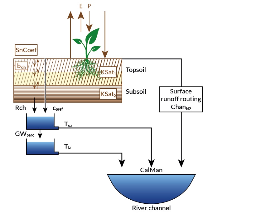
Conceptual diagram of the major hydrological processes in the LISFLOOD model
EFAS Forecasts and Products
EFAS forecasts are produced by forcing the LISFLOOD hydrological model with a range of meteorological forecasts. They consist of daily and 6-hourly discharge time series for every grid cell of the river network, starting the day of the forecast and ending the last day of the meteorological forecast forcing.
Different types of meteorological forecast forcings are used in EFAS: deterministic forcings (i.e. single realisation from a single model) and ensemble forcings (i.e. multiple realisations -also called ensemble members - from a single model). Probabilistic hydrological forecasts are issued based on the latter and give a quantifiable range of most probable future states. Discussions on ensemble in flood forecasting and associated scientific advances can be found for example in the HEPEX blogs.
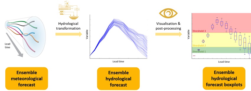
Schematic of ensemble forecasting
EFAS products are a set of maps and graphs that highlight possible future flood risk from the EFAS forecast simulations. They are produced by comparing the forecasts with reference flood thresholds, and categorised in different lead-time:
- Flash flood indicators: they provide indication of risk of flooding from flash floods, up to 5 days
- Medium-range flood forecasts: they give overview of upcoming flood events for the next 10 days
- Seasonal hydrological outlooks: they summarise the hydrological situation over the next 8 weeks
- Flood impact forecasts: they highlight regions with expected impacts in the next 10 days
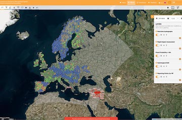
EFAS products are produced by COMP and can be viewed through the EFAS mapviewer under the categories ‘Flood summary’, 'Hydrological' and ‘Flash Flood’.
To respect Member States authorities regarding flood warnings, some EFAS forecasts and products are only accessible to EFAS partners in real time. However, archived EFAS forecasts and products older than one month are freely accessible under specific terms and conditions. To learn more on EFAS data restrictions and terms and conditions, visit the data access pages.
EFAS Versioning
The EFAS system undergoes constant changes and improvements, both in the modelling system and the products that are produced for the web and web services. To make it possible for the EFAS users to understand and adapt to changes that might affect their work, all changes are collected into official EFAS and are given an EFAS version number. The version number has two digits, the first marks a major release, and the second a minor. A major release consists of changes that will have affect the EFAS operational centres or ERCC. Please see our EFAS wiki for more information EFAS versions and planned releases.
EFAS Flood Notifications
EFAS Flood notifications are issued by the EFAS duty forecasts to highlight potential future flood event. There are based on EFAS flash flood and medium range forecasts, and classified in three types of notifications: Formal notification, Informal notifications and Flash Flood notifications. All notifications are sent to EFAS partners and the ERCC once issued, and shown on the map viewer by activating the ‘active notifications’ layer. EFAS notifications are the responsibility of CEMS Hydrological Forecast Centre - Analytics and Dissemination (DISS)