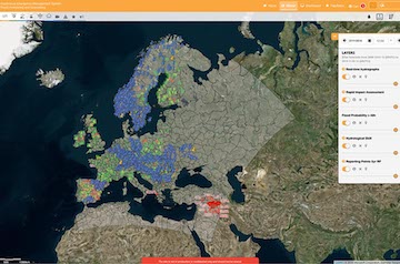
EFAS provides different flash flood indicators based on two main concepts: 1) ERIC, generated from high-resolution numerical weather predictions with a lead time of up to 5 days, and 2) TAMIR, combining radar precipitation products and ensemble NWP medium range precipitation forecasts for the next 120 hours.
ERIC - Numerical weather prediction based flash flood indicator
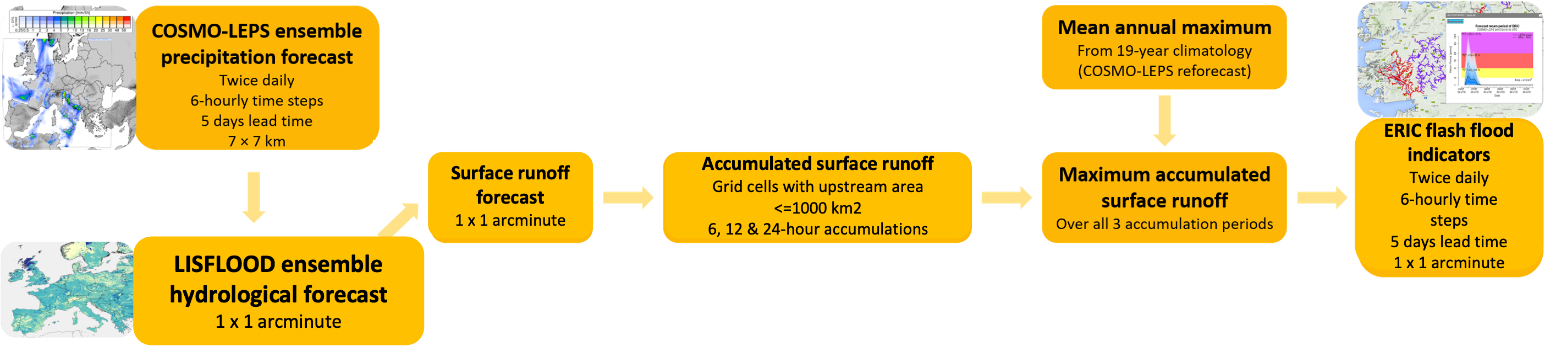
The ERIC flash-flood indicator is generated by comparing the forecasted surface runoff accumulated over the upstream catchment with a reference threshold. It is based on the 20-member COSMO-LEPS ensemble precipitation forecasts from the LISFLOOD hydrological model and provides indicators of flash flooding for the next 5 days.
Two ERIC products exist:
- Reporting points (“ERIC Reporting Points” layer): points in the river network where flash flooding is possible. Enlarged triangles highlight where the flash flood forecast probability over the next 5 days meets the notification criteria in terms of threshold exceedance probability and lead time of threshold exceedance (Find the criteria in the EFAS Wiki under ERIC reporting points). The ERIC reporting points provide the fundamental information upon which Flash Flood Notifications are generated and then distributed to the EFAS partners.
- Affected area (“ERIC Affected Area” layer): river network which contributes to each ERIC reporting point, i.e. areas at risk from flash flooding. Read more in the Wiki under ERIC Affected Area.
Advanced Tools for pro-Active Management of Impacts and Risks induced by convective weather, heavy rain and flash floods in Europe
In addition to the ERIC, there are several TAMIR products available in the EFAS Map Viewer, aiming to forecast the potential areas which may be affected by riverine flash flooding due to heavy rainfall. This product combines radar precipitation products (OPERA) and ensemble NWP medium range precipitation forecasts. The precipitation forecast is then translated into a flood impact product, by accumulating the precipitation data on the a river channel network, comparing it against climatological thresholds, and then overlaying it with expusure data (such as population and critical infrastructure data).