
Navigazione principale

  • About
  • Products
  • Data access
  • Collaborate
  • News and events
  • Resources
  • Training
  • Notifications
  • EFAS Wiki

News

Event

2020-10-22
EFAS logo
EFAS Annual Meeting 2020 - Online

News

2020-10-16
Flooding from the Owenglin river in Clifden, 02 September 2020. Credit: Elena Vaughan, published with permission
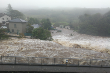
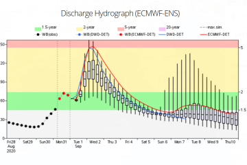
Flooding in County Galway, Ireland, September 2020

News

2020-10-15
Example of the 6-hourly water balance and ECMWF-ENS driven medium range forecasts available through EFAS v4.0
EFAS 4.0 - New version of EFAS launched

News

2020-10-14
EFAS Partner Regions
New EFAS Research partner (ARGANS)

News

2020-10-14
EFAS Partner Regions
New EFAS Third Party (National Fire and Rescue Authority, Israel)

News

2020-10-01
Copernicus Hackathon 2020
Copernicus Hackathon, 16-17-18 October 2020

News

2020-09-02
EFAS Partner Regions
New EFAS Third Party (National Authority for Emergency and Civil Protection, Portugal)

News

2020-08-10
A flood damaged bridge in western Ukraine, June 2020. Source: National State Emergency Service of Ukraine
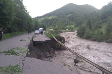
Flooding in western Ukraine, June 2020

News

2020-08-03
The Initial Hydrological Conditions (IHCs) in GloFAS.
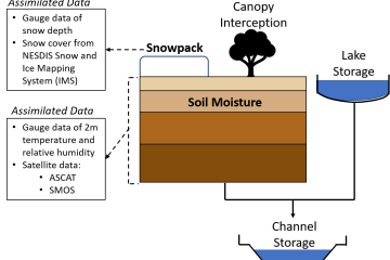
Investigating how satellite soil moisture data could improve streamflow predictions

News

2020-07-30
Zagreb city centre under water, 24/25th July 2020.
Urban flash flood in Zagreb Croatia, July 2020

Pagination

  • Previous page ‹‹
  • Page 24
  • Next page ››

Map viewer

Training

Data Download

Copernicus Services:
Atmosphere Marine Land Security Climate Change Emergency
Contact
Follow us
Copernicus

Copernicus is an EU programme aimed at developing European information services based on satellite Earth Observation and in situ (non space) data. Copernicus is a user driven programme and the information services provided will be freely and openly accessible to its Users, mostly public authorities.

  • Terms and conditions
  • Privacy statement
  • Cookies
  • feed rss RSS
  • Contact us