by Calum Baugh, Patricia de Rosnay, Heather Lawrence, Toni Jurlina, Ervin Zsoter, Christel Prudhomme (all ECMWF); Matthias Drusch (European Space Agency - ESA).
In order to make an accurate forecast of streamflow it is necessary to know the quantity of water stored in the catchment at the start of the forecast. These are called the initial hydrological conditions (IHCs) and includes water stored in the snowpack, river channel, lakes, vegetation canopy and soil moisture. Improving the accuracy of the IHCs could improve the accuracy of the subsequent streamflow forecasts.
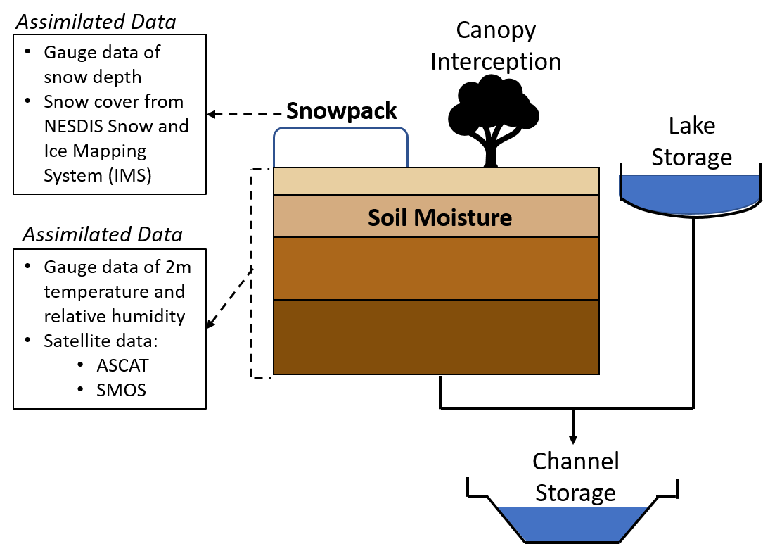
The IHCs for forecasts of the Global Flood Awareness System of the Copernicus Emergency Management Service, GloFAS, are produced by the European Centre for Medium Range Weather Forecasts Land Data Assimilation System (ECMWF LDAS 2019) which combines (assimilates) observations from in-situ and satellite based sensors (Figure 1) with a first guess of the IHCs from the previous forecast. Meanwhile the IHCs used in the European Flood Awareness System (EFAS) are derived from in-situ observations of temperature, precipitation and wind speed.
Of the IHCs it has been shown that having an accurate estimate of the initial soil moisture conditions can often have the greatest positive impact upon the streamflow predictability. In EFAS, no direct observations of soil moisture are used to estimate its IHC. In GloFAS however, its initial soil moisture conditions produced by the ECMWF LDAS use observations from the Advanced Scatterometer (ASCAT) satellite and in-situ observations of 2 metre temperature and relative humidity. Since the release of ECMWF model cycle 46r1 in June 2019, the ECMWF LDAS estimation of initial soil moisture conditions also included observations from the Soil Moisture Ocean Salinity (SMOS) satellite (Figure 1). This addition of SMOS provided the opportunity to investigate the impact upon the accuracy of the GloFAS streamflow predictions.
The Soil Moisture Ocean Salinity (SMOS) measurements.
SMOS was launched in November 2009 by European Space Agency (ESA). It carries an L-band radiometer which measures brightness temperature emitted by the earth’s surface at a frequency (1400-1427 MHz) which is sensitive to soil moisture in the top few centimetres of the soil layer (Kerr et al., 2010; Mecklenburg et al., 2016). The measurements are at a spatial resolution of 43 km with a repeat cycle of less than 3 days. Brightness temperature measurements are converted into soil moisture using a neural network processor which has been trained on ECMWF LDAS soil moisture estimates (Rodriguez-Fernandez et al., 2019).
Investigating the effect of SMOS Soil Moisture data assimilation in GloFAS simulations in Australia and United States of America.
As GloFAS forecasts are initialised using IHCs from the ECMWF LDAS, a partnership between ESA and ECMWF was established to investigate whether the inclusion of SMOS soil moisture data into the LDAS affected streamflow predicted by GloFAS. Two time series of initial soil moisture conditions were produced by the ECMWF LDAS for the period March 2017 to May 2018: one time series was produced by including observations from SMOS within the LDAS, the other time series excluded the SMOS observations. Both time series were then used within GloFAS as the initial soil moisture conditions on each day during the experiment period. They were combined with other IHCs from the ECMWF LDAS and precipitation and temperature forcings from the ECMWF deterministic Numerical Weather Prediction (NWP) forecast to predict streamflow for the next 24 hours.
The GloFAS streamflow predictions were evaluated against in-situ streamflow observations at 283 locations in the United States of America (USA) and 32 in Australia by computing the modified Kling-Gupta efficiency (KGEmod) metric (Gupta et al., 2009; Kling et al., 2012). Throughout the USA KGEmod scores from the GloFAS simulations with and without the assimilation of SMOS soil moisture data were very small. The simulation with SMOS showed a very slight improvement (Table 1). In Australia the differences were also small but there, the simulation with SMOS observations showed a slight decline in the KGEmod score (Table 2).mod score (Table 2).
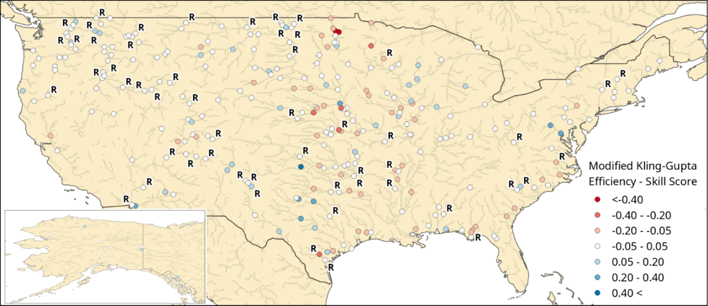
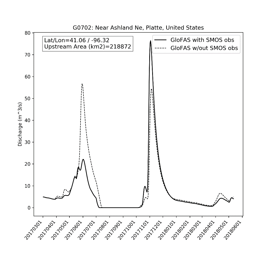
The differences in the KGEmod scores between the two GloFAS simulations at each gauging station were computed into a skill score, positive values showing an improvement in skill when SMOS data are assimilated. Results in the USA showed no clear spatial trend, with no distinctive clustering of positive or negative values (Figure 2). The strongest skill score values, of both signs, were in the central part of the country. Positive skill scores were found at 40 locations, however 31 of these locations still had a KGEmod score less than 0.40 meaning that care should be taken when interpreting the significance of the improvement. Analysing the results at these 40 locations showed that the greatest differences occurred during periods of high streamflow, for example in the Platte river, USA (Figure 3).
Investigating the effect of SMOS Soil Moisture data assimilation in GloFAS simulations over the world.
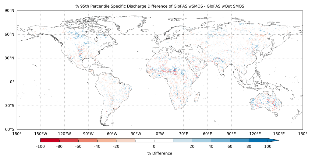
Globally the impacts of SMOS data assimilation were assessed by comparing the differences in the low and high streamflow of the two GloFAS simulations in every 0.1° model cell. Low and high streamflow were calculated as the 5th and 95th percentiles respectively over the 18-month experiment period in both GloFAS simulations. The discharge values were converted into specific discharge by dividing by the upstream area in each 0.1° GloFAS model cell, this removed the influence of catchment size. High flows showed the greatest impact of the assimilation of SMOS data, especially in the Hudson Bay, central USA, Australia, the Sahel region and to a lesser extent Pakistan/north west India and north eastern China (Figure 4). The Hudson Bay area showed a widespread increase in high flows with the assimilation of SMOS, but the other regions showed no clear spatial trend to the changes.
Conclusions and next steps
The results from this study found that the assimilation of SMOS soil moisture data did affect the streamflow predictions of GloFAS.The greatest impact was upon predicted high streamflow values. The areas which demonstrated the greatest impacts coincided with areas of open land cover, where the SMOS data are expected to have the greatest accuracy. In other areas the SMOS measurements could be degraded by vegetation cover, mountainous topography or Radio Frequency Interference (RFI). The changes in high flow could be due changes in the soil moisture affecting the generation of surface runoff, with increase possibly due to wetter soil moisture which increases the amount of runoff that is delivered to the river channels. Future work could clarify this by investigating the impacts for specific flood events.
However, the overall impact of assimilating SMOS data upon predicted GloFAS streamflow was small. This is to be expected as the SMOS instrument only measures soil moisture in the top few centimetres of the soil layer, which is a small component of the total water stored in the IHCs. Despite this, the assimilation of SMOS data could still be beneficial for GloFAS predictions, particularly of high flows. ECMWF are now working with ESA to investigate the possibility of using SMOS data to quantify the amount of water used for irrigation purposes, this is currently a poorly known component of the hydrological cycle in GloFAS.
This work has been published as a scientific article: Baugh, C.; de Rosnay, P.; Lawrence, H.; Jurlina, T.; Drusch, M.; Zsoter, E.; Prudhomme, C. The Impact of SMOS Soil Moisture Data Assimilation within the Operational Global Flood Awareness System (GloFAS). Remote Sensing. 2020, 12, 1490. https://doi.org/10.3390/rs12091490
References:
ECMWF Part II: Data Assimilation. In ECMWF (eds) IFS Documentation CY46R1 Operational Implementation 6 June 2019, ECMWF, Reading, 2019 103pp, https://www.ecmwf.int/en/elibrary/19306-part-ii-data-assimilation (accessed on 30th March 2020).
Gupta, H.V., Kling, H., Yilmaz, K.K., Martinez, G.F. Decomposition of the mean squared error and NSE performance criteria: Implications for improving hydrological modelling. Journal of Hydrology 2009 377(1-2), pp. 80-91. Doi.org/10.1016/j.jhydrol.2009.08.003
Kerr, Y.H. ,P. Waldteufel, J.-P. Wigneron, F. Cabot, J. Boutin, M. Escorihuela, J. Font, N. Reul, C. Gruhier, S. Juglea, S. Delwart, M. Drinkwater, A. Hahne, M. Martin-Neira, S. Mecklenburg. The SMOS mission: new tool for monitoring key elements of the global water cycle Proc. IEEE, 98 (5) (2010), pp. 666-687, 10.1109/JPROC.2010.2043032
Kling, H., Fuchs, M., Paulin, M. Runoff conditions in the upper Danube basin under an ensemble of climate change scenarios. Journal of Hydrology 2012 424-425, pp. 264-277. Doi.org/10.1016/j.jhydrol.2012.01.011
Mecklenburg S., M. Drusch, L. Kaleschke, N. Rodriguez-Fernandez, N. Reul, Y. Kerr, J. Font, M. Martin-Neira, R. Oliva, E. Daganzo-Eusebio, J.P. Grant, R. Sabia, G. Macelloni, K. Rautiainen, J. Fauste, P. de Rosnay, J. Muñoz-Sabater, N. Verhoest, H. Lievens, S. Delwart, R. Crapolicchio, A. de la Fuente, M. Kornber: ESA's Soil Moisture and Ocean Salinity mission: From science to operational applications, Remote Sensing of Environment, vol 180, pp 3-18, 2016, doi:10.1016/j.rse.2015.12.025
Rodriguez-Fernandez, N., de Rosnay P., Albergel C., Richaume P., Aires F., Prigent C., Kerr Y.: "SMOS Neural Network Soil Moisture Data Assimilation in a Land Surface Model and Atmospheric Impact", Remote Sensing, 11(11), 1334, 2019 https://www.mdpi.com/2072-4292/11/11/1334
