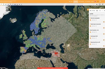
The European Flood Awareness System (EFAS) is one service of the Copernicus Management Service CEMS. It is designed to support preparatory measures for flood events across Europe, particularly in large trans-national river basins.
To provide information on upcoming flood events, EFAS relies on a hydrological forecasting chain

The EFAS hydrological forecasting chain
There are key elements in the EFAS production chain: the meteorological forcing and land surface data; the hydrological models; and the EFAS forecasts and products.
The meteorological forcing and land surface data
The meteorological forcing data are all the information necessary to produce hydrological simulations. They include:
- Historical hydro-meteorological time series records. They are used to calibrate the hydrological model, and to define the flood thresholds used to derive EFAS products. They are collected and managed by the JRC with contributions from MDCC, HDCC and COMP
- Real-time hydro-meteorological observations. They are necessary to define the starting points of the hydrological forecasts, also called initial conditions. They are collected from national agencies and quality checked by the EFAS Meteorological and Hydrological Data Collection Centres (MDCC and HDCC respectively) before being transferred to the EFAS Computation Centre (COMP).
- Meteorological forecasts. They are used to provide the future meteorological input to the hydrological models. Both deterministic (i.e single realisation from a single numerical weather prediction system) and ensemble (i.e. multiple realisations -also called ensemble members - from a single numerical weather prediction system) forecasts are used in EFAS, obtained from a range of providers.
LISFLOOD – the hydrological model for EFAS
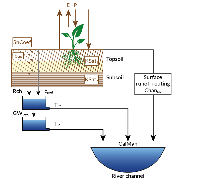
Most of EFAS flood forecast products are based on outputs from LISFLOOD, a spatially distributed rainfall-runoff model with a one-dimensional hydrodynamic channel routing component. LISFLOOD is being developed at the Joint Research Centre since 2000, and has been used for operational flood forecasting at pan-European scale since the beginning of EFAS. Driven by meteorological forcing data (precipitation, temperature, potential evapotranspiration, and evaporation rates for open water and bare soil surfaces), LISFLOOD calculates a complete water balance at a 6-hourly or daily time step for every 5km grid-cell of the EFAS domain.
Processes simulated for each grid cell include snowmelt, soil freezing, surface runoff, infiltration into the soil, preferential flow, redistribution of soil moisture within the soil profile, drainage of water to the groundwater system, groundwater storage, and groundwater base flow. Runoff produced for every grid cell is then routed through the river network using a kinematic wave approach. The model also includes options to simulate lakes and reservoirs as well as water abstraction.
LISFLOOD is coded using the Python programming language and PCRaster Python extension, which enables use of the PCRaster modelling engine from Python. The NetCDF file format was adopted for inputs and outputs. Efforts to make LISFLOOD a full open-source model are ongoing.
Reducing false alarms – threshold exceedance and persistence
EFAS is sending flood notifications to its partners only when there is a danger that critical flood levels might be exceeded. In EFAS, the critical thresholds are needed at every grid point and therefore cannot be derived from observations. Instead, based on observed meteorological data, long term discharge time series are calculated at each grid with the same LISFLOOD model parameterization that is set up in the forecasting system. From these long-term simulations return periods are estimated at every pixel and the threshold exceedance calculated. Only when critical thresholds are exceeded persistently over several forecasts EFAS flood notifications are sent to the partners. The persistence criteria has been introduced to reduce the number of false alarms and focus on large fluvial floods caused mainly by widespread severe precipitation, combined rainfall with snow-melting or prolonged rainfalls of medium intensity.