By Cinzia Mazzetti, Mercedes Garcia Padilla, Rafael Garcia and Christel Prudhomme
Call for data: EFAS partners can submit feedback on calibration stations until 30th June
As a starting point, EFAS Computational Centre (COMP) will consider all stations used for EFAS v4 calibration but will also assess if more stations in the EFAS Hydrological Data Collection Centre (HYDRO) database could be used for EFAS-next calibration. The selection process has already started, but there is still the opportunity for EFAS partners to contribute with new discharge data and take part in the selection of EFAS-next calibration stations! There are two ways you can take part:
- In the next few weeks, COMP and HYDRO will contact you with a list of already pre-selected calibration stations, and alternative/new candidates for EFAS-next. You can then provide feedback on the stations, for example by letting us know which stations should be avoided (e.g. because very old and no longer in use, or because of issues with the rating curve or the sensor), replaced by alternative stations nearby already within the HYDRO database, or by offering new stations.
- You can also contact HYDRO directly with new river discharge data. As described below (in the "Identification of calibration stations" section), the length and quality of the river discharge time series observation are not the only criteria for selection, and it might be possible that a new candidate is not selected at the end, for example, if it cannot be located accurately in the EFAS river network. However, this is seldom the case.
Increasing the calibration domain (i.e. with more stations and longer time series) is a great way to improve the quality of the EFAS system, and we are very much looking forward to working with you to achieve this. However, as mapping and additional quality check procedures are long, we can only accept new candidate stations for EFAS-next calibration until the 30th June 2021, so that we have time to inspect the data before the calibration starts. Any data received after that date will of course be included in the HYDRO database and considered for future EFAS upgrades such as reporting point upgrades or another cycle of calibration.
Background
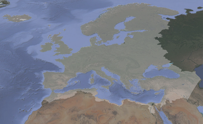
Like any operational forecasting systems, EFAS is always evolving with regular updates of the modelling chain, products, or information access. The latest upgrade, EFAS v4.2, includes 436 new fixed reporting points on the EFAS mapviewer (bringing the total number to 3087) so that users can monitor forecasts at their stations of interest. The next step-change in the EFAS modelling chain is an increase of the spatial resolution to a 1 arcminute grid (around 1.19km size at 50° latitude) with a small eastward widening of the domain, giving around 22 times more grid points compared with the EFAS v4 5-km grid (Figure 1). The resolution increase will come with a new calibration, which provides an opportunity for adding more calibration points.
Hydrological model calibration
LISFLOOD is the hydrological model at the heart of EFAS. Developed at the JRC since 2000, it is now fully open-source maintained by the JRC with the support of the EFAS COMP at ECMWF.
LISFLOOD is a fully distributed hydrological model, which explicitly considers the spatial distribution of physical properties across catchments and provides estimates of river discharge on the entire geographical domain. Driven by meteorological forcing data, LISFLOOD calculates a complete water balance for every grid cell, with runoff then routed through the river network using a kinematic wave approach, including options to simulate lakes and reservoirs. The water balance estimates and routing rely on a set of parameters conceptualising the different hydrological processes.
Where long enough, good quality river discharge time-series observations are available, parameter sets are searched iteratively and tested by comparing observed time-series with LISFLOOD simulations forced with observed meteorological maps so that the parameter set best representing the hydrological behaviour of the catchment can be identified. This is a process known as ‘hydrological model calibration’. For catchments where there are no observations, default parameters are used along with land surface information when running LISFLOOD.
EFAS Calibration domain
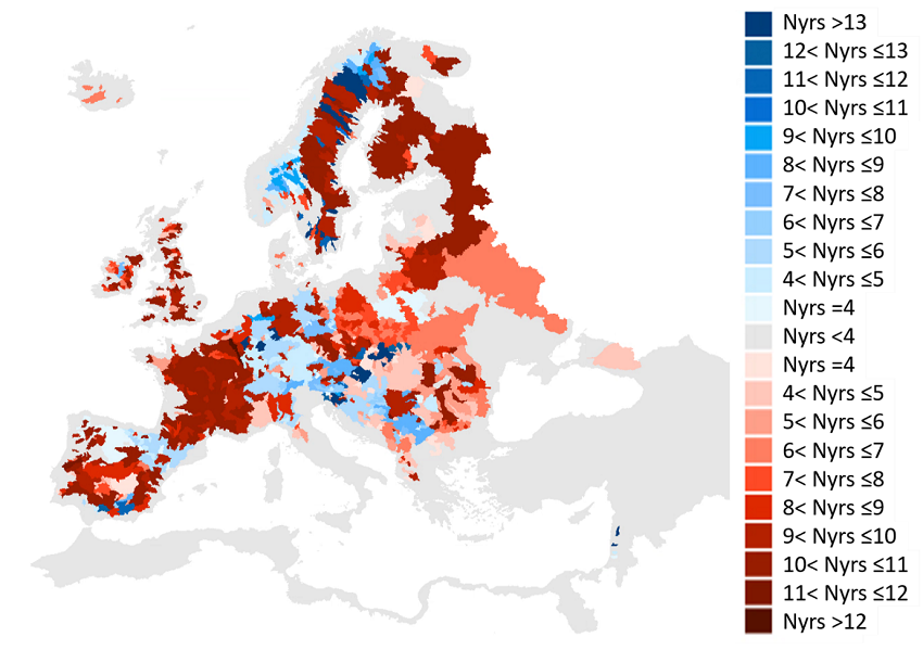
The calibration process results in an improvement in the hydrological simulation performance. For EFAS to benefit from the best hydrological simulation everywhere, the catchments represented by the calibration stations should cover the largest area possible. For EFAS v4.0, calibration was performed using data from 1137 stations in 215 river basins covering 44.49% of the 9 million km2 EFAS spatial domain (Figure 2). The calibration stations were selected from the 2927 river gauging stations in the HYDRO database in July 2018 when calibration work began. Because of the limited availability of sub-daily river discharge data, catchment with 6-hourly data (the time step of EFAS from version 4) and daily data were both considered, which increased by 180% the calibration points against only using 6-hourly data.

Since then, the amount of river discharge time-series available in the HYDRO database has increased, benefiting from more data providers and a longer period of record. This gives an opportunity to extend the EFAS calibration domain for EFAS-next.
Identification of calibration stations
Not all stations with records available in the HYDRO database are appropriate for the EFAS calibration. First, the calibration relies on river discharge and stations with river level only data (and no rating curve) cannot be used. Second, the period of observational record needs to match with observed meteorological forcing data (1990 - 2021) and include at least 4 years of data. Third, the location of the station and the quality of the data are also considered so that the best overall calibration coverage can be achieved.
Locating the station on the EFAS river network
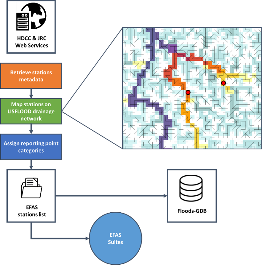
As already said, LISFLOOD is a distributed model based on a mesh of points organised on a regular grid. For EFAS-next, the grid has a 1 arcmin size. Using elevation information, LISFLOOD pixels are connected to reproduce the natural drainage network, but the spatial resolution of the grid and inaccuracies in pixels elevation can affect the representation of rivers in LISFLOOD from the real world. It is generally not a problem for hydrological modelling, but it becomes an issue when the drainage network of the model is compared to real-world locations. This means that it is necessary to map each gauge to the pixel where discharge from the model can best represent observations at the station. This is a long process based on metadata information (e.g. catchment area, river/station name) and manual inspections (e.g. using Google maps). Location of the station relative to river confluence (i.e. upstream or downstream) and/or presence of lakes and reservoirs are also considered, and if necessary, river gauges location on EFAS grid are shifted from their geographical coordinates by few pixels. Any error or inaccuracy in river stations metadata are reported to the HYDRO and stations that could not be mapped onto the model drainage network are flagged. The workflow involved is shown in Figure 3.

River discharge data check
Data in the HYDRO database are inspected by COMP to identify available record length, low-quality data (e.g. missing/invalid data, outliers, location error), or influenced regime (e.g. from reservoirs/lakes). This is done using automatic procedures, statistical analysis (e.g. flow duration curves, annual hydrograph, annual totals) and visual time-series inspections. In addition to acceptable quality and reduced influence from reservoirs and lakes, calibration stations are selected according to the following criteria:
- Drained area: > 500 km2 for EFAS 5-km grid. For EFAS-next, we now consider stations for catchments larger than 200 km2.
- Record length: >= 4 years (excluding missing data)
- Time step: sub-daily or daily (both historical and near real-time data are considered)
- Spatial coverage: as large as possible, including some tolerance on data quality and availability but excluding nearby stations on the same river branch, prioritising first sub-daily data and then longest available record
Part of the quality check procedure is the consistency between discharge values at adjacent river stations on the same river, the removal of outliers and suspicious zeros, and visual inspection of the time-series. At the end of the process, a data quality flag is associated with the station.
Don't forget to submit your feedback on calibration stations until 30th June!

