by Ervin Zsoter, Christel Prudhomme and Corentin Carton De Wiart, EFAS Computational Centre
The weather was wetter than normal in many regions in Europe during May, such as most parts of Scandinavia and Central Europe. One area standing out was the central Mediterranean, being exceptionally wet during the whole of May. According to the ERA5 reanalysis, some parts of Italy did experience at least 2-3 times the monthly average rainfall. There were periods of heavy rain that lead to severe flash floods and riverine floods in many areas, associated with increased landslide risk in some places.
Flood analysis
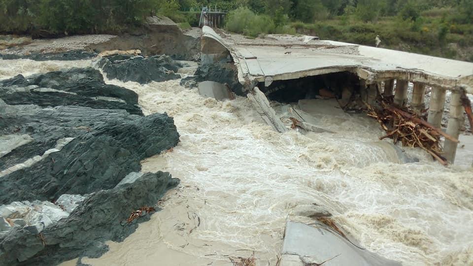
One of the badly hit areas was Emilia-Romagna which experienced severe floods on around 13 May. Some rivers were out of their banks with train lines closed and bridges damaged. The worst impacted area was the regions of the Savio and Marecchia rivers near San Marino, where in two days up to 150-200 mm rain was observed in the upstream part of these rivers. Other areas were also under severe flood threat, like the Secchia and Panaro rivers in the province of Modena, where precautionary measure, including road and bridge closures, were in place due to the expected high river levels.

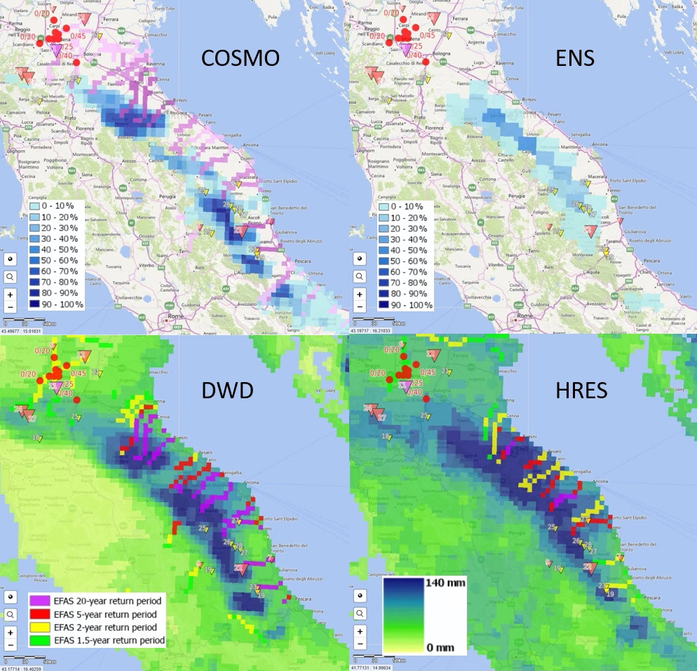
The performance of EFAS forecasts was rather mixed for this event in Emilia-Romagna (Figure above). Analysis of the four hydro-meteorological forecast chains used in EFAS (with different meteorological forcings) run on 12 May at 00 UTC showed large differences between the forecasts. COSMO-LEPS- and DWD-driven forecasts (left) showed a good hydrological signal for the worst impacted area west and northwest of San Marino. This can be attributed to a good precipitation forecast, and associated river response in EFAS with 5- and 20-year level floods (DWD) and high probability of exceeding 20-year level flood (COSMO-LEPS). The forecasts driven by ECMWF-HRES and ECMWF-ENS did not show the same severity in the flood signal, with muted river discharge response of ECMWF-HRES to surprisingly large 10-day precipitation total, and ECMWF-ENS showing no probability for flood greater than 20-year level, despite up to 20-30% probability of 10-day precipitation exceeding 150 mm in the area.
Defining reporting points
The high uncertainty in the meteorological forcing, the large variation in the forecasts from one forecast run to another and the short duration of the event, made it difficult to define reporting points in EFAS (river basins where flood hazard is consistently forecasted to be large). Indeed, EFAS combines all the forecasts together creating a multi-model ensemble where the ECMWF-ENS, due to its high number of ensemble members, tends to have a larger weight in the outputs. In addition, ECMWF-ENS forecasts are still simulated using a daily time step which leads to a smoothing of flood peaks in small, fast responding catchments as is the case for this event. Furthermore, due to the spatial resolution of the hydrological model in EFAS (25km2 per pixel) small catchments as the Savio and Marecchia rivers (approx. 1000km2) tend to have lower forecast skill. Finally, the COSMO-LEPS-driven flash flood indicator missed some of the worst impacted rivers (despite showing signal both north and south of the region), possibly because of a relatively dry soil in the model south from Bologna.
Towards fixed reporting points
One of the issues with this event was the fact that no reporting point was shown in the worst hit area, so that flood forecasters could not investigate in detail the shape of the flood hydrographs. The introduction of fixed reporting points, where flood hydrographs are always produced for a number of river basins with available hydrological data, should help with such cases. Such an upgrade is currently investigated and will be fully tested in EFAS during the summer 2019, anticipated to be part of the production suite in the autumn. In addition, the way reporting points are identified and shown could also be revised, for example with more flexible rules regarding the forecast uncertainties. However, the multiplication of reporting points associated with lower probability of flooding might make the interpretation of the forecasts more difficult.
Planned model upgrades
Furthermore, it is foreseen to switch also the ECMWF-ENS driven EFAS forecasts using a 6 hourly time-step. For this purpose a hydrologic model calibration using a 6-hourly time-step is currently ongoing and will be released in spring 2020. This is expected to improve forecast skill for fast responding catchments. Finally, preparations have already been started to increase the spatial resolution of the hydrological model with the aim to create higher-resolution EFAS forecasts in the coming years.

